The civil servants who drew up boundaries of registration districts in the 1830s were surprisingly modernist. They took scant regard of the boundaries of traditional counties, unchanged for centuries, crossing them whenever they wanted. Launceston Registration District (RD) for example included parishes in west Devon while Calstock was for a time part of the Tavistock RD.

I’ve taken equal liberties with the RD boundaries, placing Calstock with its neighbouring parishes of Callington from Liskeard RD, Stokeclimsland from Launceston RD and St Dominick from St Germans RD. Doing so allows an interesting contrast to emerge between the remainder of the St Germans district and my new Calstock and surrounding district.
In the 19th century and earlier, St Germans was the least ‘Cornish’ of Cornwall’s RDs. A higher density of great houses, more attendance at Anglican churches and the influence of Plymouth just over the river accompanied a predominantly farming countryside with very little mining or other industrial activities. In contrast, the parishes in my expanded Calstock district all contained significant mining activity at times in the 1800s.
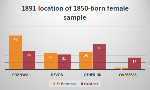

As we can see, this was reflected in major differences in their migration patterns. The St Germans born children of 1850 were more likely to stay in Cornwall or to be found in neighbouring Devon, less likely to make longer-distance moves within the UK and much less likely to have gone overseas. Boys and girls shared this profile, the only difference being that St Germans-born girls were more likely to be found in Devon in middle age than in Cornwall. This reflected the pull of the demand from Plymouth for female labour in this far south-eastern corner of Cornwall.
